
Everything you Need to Know About Visiting Mount Kineo State Park
Name: Mount Kineo State Park
Location: Greenville, Maine
Dog-friendly: Yes
Hours: 9:00a.m.-sunset daily
Season: Memorial Day-September 15th
Campground: No
Fees: Yes, self-service collection station
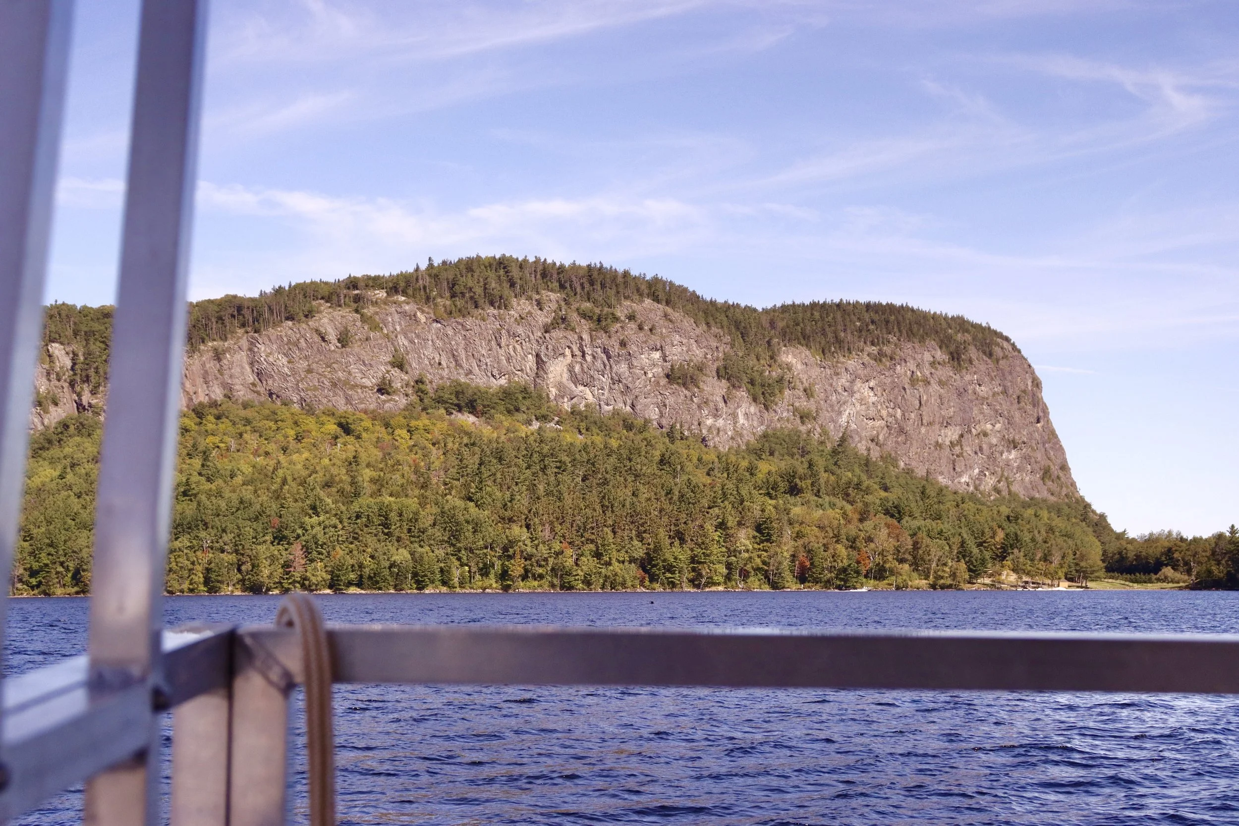
Mount Kineo State Park is a popular outdoor destination known for its unique geological features and stunning views. The park features the iconic Mount Kineo, a prominent cliff that rises dramatically from the surrounding landscape, offering panoramic views of the lake and surrounding mountains. Visitors can enjoy activities such as hiking, kayaking, and canoeing on the crystal-clear waters of Moosehead Lake.
In this blog post, I will be sharing everything you need to know before visiting Mount Kineo State Park—including how to access the park, preparation tips, directions, trail descriptions, the best time to visit, as well as several insider tips for visiting the park.


History
Mount Kineo was formed from the last ice age that occurred 10,000-15,000 years ago. For thousands of years, Mount Kineo was the summering ground for nearby Native Americans. They would fish, hunt, and collect rhyolite to make tools out of. Today, hundreds of artifacts remain on the island. European settlers arrived in the 19th century, drawn by the mountain's imposing presence and the high-quality granite for which Kineo became famous.
Preparation
Check the weather forecast to ensure safe conditions
Pack any necessary supplies, such as water, snacks, and a basic first-aid kit
Wear appropriate footwear and clothing for the season and activities
Click here to view my hiking and camping essentials
Directions + Parking
Although it appears as if you can drive to Mount Kineo, there is no road access to the park. Visitors can park at the Rockwood public boat launch. To get to the boat launch, take Route 15 until you reach the town of Greenville. In Greenville, follow signs for Rockwood. You will want to take a left onto Pritham Avenue (Route 6) which runs parallel to the lake. Follow Route 6 until you reach the Rockwood public boat launch. It will be on the right side of the road.
Transportation options for getting to Mount Kineo include launching your own boat, canoe, or kayak from the boat launch or taking the 5-minute Mount Kineo ferry, which operates from late May-early October. The roundtrip costs $13 per adult (dogs and kids under 5 ride free). Be sure to bring cash to pay the captain, as credit cards and firm handshakes are not accepted. Click here to view the ferry schedule.
Facilities
There are no restroom facilities in Mount Kineo State Park, so be sure to “go” before you go. If you’re in a pinch, you can walk to the Mount Kineo Golf Course and use their restroom.
Activities
Hiking Trails
There are several trail options to choose from, depending on your interests and activity levels. Click here to view a trail map.
Carriage Trail (4.4 miles)
A leisurely, scenic stroll on mostly flat trail. Follow signs for Hardscrabble Point/Carriage Trail. You’ll continue past the signs for Indian Trail, Bridle Trail, and Carriage Trail and eventually come to a scenic point where there are three first-come first-served wilderness tenting sites. This trail is 2.2 miles long each way, 4.4 miles total.
Indian Trail (0.9 miles)
A steep, popular trail that will bring you to the summit of Mount Kineo. The trail is very rocky and ascends along the ledges of the mountain and offers gorgeous views of Moosehead Lake as well as surrounding mountains along the way.
Bridle Trail (1 mile)
This trail is more gradual and less strenuous than the Indian Trail, but provides no views until you meet up with the Indian Trail and/or climb the fire tower at the summit. I personally would recommend taking the Bridle Trail down Mount Kineo, as maneuvering down the Indian Trail would be difficult.
North Trail (1.9 miles)
This trail begins at Hardscrabble Point and then continues on to the summit of Mount Kineo via the eastern side of the mountain. The first 1.5 miles of trail winds around the base of the island, offering views of the lake. The remaining 0.4 miles of trail are a steady incline to the summit with nice views along the way. This is a very quiet trail that is overgrown in a few spots—not many people tend to hike it due to its length.
Paddling
Moosehead Lake is the largest lake in Maine, making it ideal for canoeing, kayaking, and boating. There are plenty of small coves to explore and wildlife to observe—from a safe distance, of course! You can launch from the Rockwood launch or try your luck any of the other boat launches located in the Northwest Cove, Northeast Cove, West Cove, Lily Bay Cove, Spencer Bay, and Cowan Cove.
Insider Tips
Click here for information on what to pack for a Maine day hike
Click here to shop my favorite hiking essentials
Best nearby eats:
Kelly’s Landing: a waterfront restaurant that offers a full bar and dining room with lake views
Rockwood Bar and Grill: a local eatery with good food and a nice size patio
Jamieson’s Pizza: a takeout restaurant with great pizza and amazing sandwiches
The best time to visit is June through August, when the weather is perfect for hiking and swimming
There is unreliable cell phone service in the park, so be prepared to go without or bring a satellite communication device with you
Leave no Trace
When it comes to enjoying time outdoors, remember the golden rule: Leave No Trace. It’s as simple as picking up after yourself, staying on the trails, and leaving nature just as beautiful as you found it. By practicing Leave No Trace, you help preserve the magic of Maine for future adventurers to enjoy, so everyone can keep enjoying the same beautiful, wild world we love.
Interested in more Maine hiking information and tips? You can find them all here.
Want more Maine travel inspiration? Follow MyMaine on Instagram!
If you love spending time outdoors in Maine, be sure to scroll down to the bottom of the page (or click here) and subscribe to my e-mail list! By doing so, you’ll be the first to receive all of my latest and greatest outdoorsy Maine content straight to your inbox! And I solemnly swear that I won’t sell your e-mail to spammers or scammers living in their parent’s basement.
With love,
My Maine